
Drone mapping has transformed industries such as construction, agriculture, surveying, mining, and infrastructure inspection. However, capturing aerial images is only one part of creating accurate maps. The quality of the final data depends on how well the images are positioned and corrected.
Aerial mapping GCPs (Ground Control Points) help improve the accuracy of drone-generated maps by providing fixed reference locations on the ground. These points allow mapping software to align aerial images with real-world coordinates, resulting in more precise measurements and reliable survey outputs.
What Are Aerial Mapping GCPs?
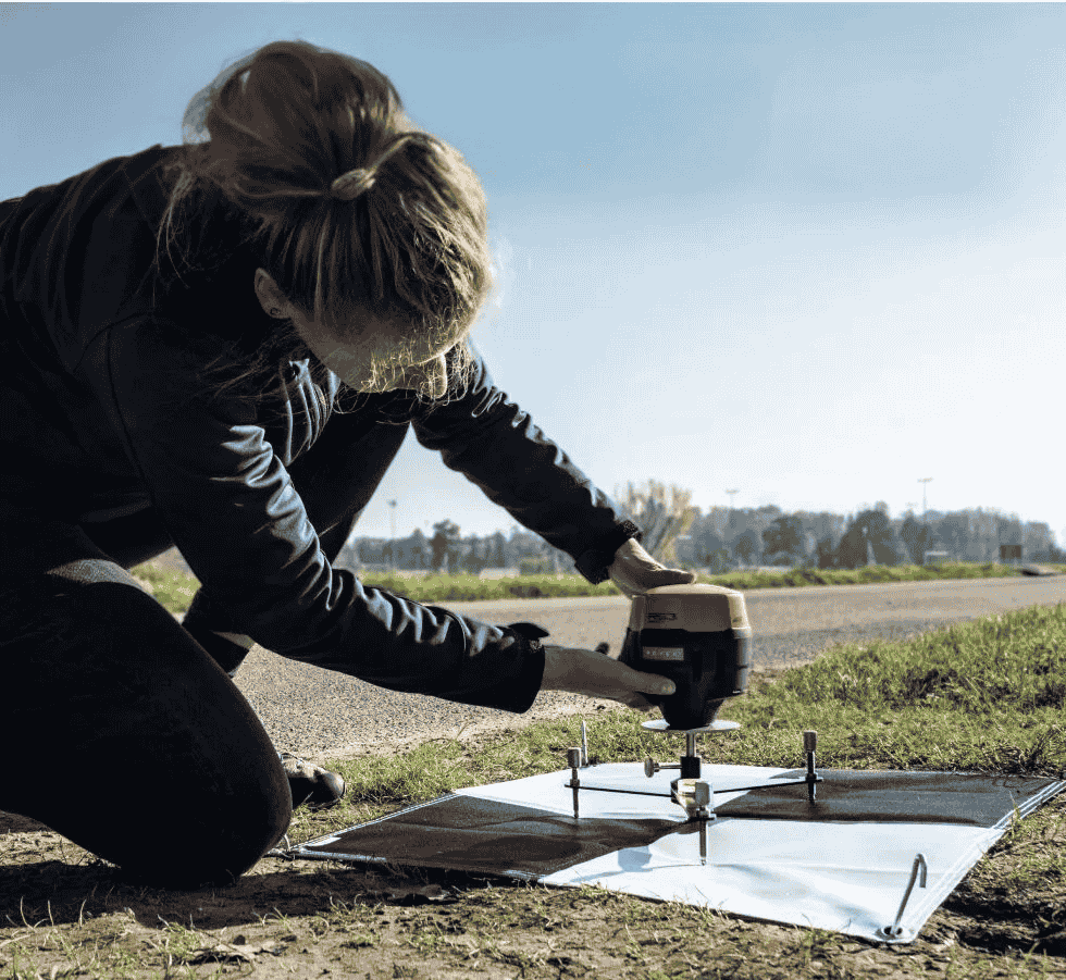
Ground Control Points are clearly marked locations on the ground with accurately measured geographic coordinates. During a drone survey, these points appear in aerial photographs and help software understand the exact position and scale of the captured data.
GCPs act as reference markers that connect drone imagery with real-world locations. They are especially useful when projects require high accuracy for measurements, analysis, and decision-making.
Common uses of GCPs include:
- Creating accurate orthomosaic maps
- Improving 3D models
- Supporting land surveys
- Measuring distances, areas, and volumes
- Reducing positioning errors in drone data
Without proper ground references, drone maps may contain location errors caused by GPS limitations, camera angles, or environmental conditions.
Why Are GCPs Important for Drone Mapping Accuracy?
Drone cameras capture detailed images, but the onboard GPS system may not always provide survey-grade accuracy. Small positioning errors can affect the final map, especially in large areas or projects requiring precise measurements.
Using ground control points helps correct these errors during data processing.
Improved Geospatial Accuracy
GCPs improve the connection between aerial imagery and actual ground locations. This creates more accurate mapping results that professionals can trust for planning and analysis.
Better Measurement Results
Accurate reference points allow users to perform reliable calculations, including:
- Land area measurements
- Stockpile volume calculations
- Construction progress tracking
- Terrain analysis
Reduced Image Distortion
Drone images can experience slight shifts due to altitude changes, camera angles, and terrain variations. Control points help software adjust these differences and create a more accurate final output.
How to Set Up GCPs for Drone Mapping
Proper placement and measurement of ground control points are essential for achieving high-quality results.
1. Plan GCP Locations Before Flying
Before starting a drone mission, analyze the survey area and decide where control points should be placed.
Good placement includes:
- Corners of the mapping area
- Center locations
- Areas with elevation changes
- Easily visible locations from above
Even distribution helps the processing software accurately adjust the entire map.
2. Use Visible Ground Targets
Ground markers should be easy to identify in aerial images. High-contrast targets help mapping software locate the exact reference points.
Common GCP target materials include:
- Painted markers
- Plastic panels
- Survey flags
- Professional mapping targets
The size of the target depends on flight altitude and camera resolution.
3. Measure Coordinates Accurately
The accuracy of your final map depends on the quality of GCP measurements. Survey-grade equipment such as RTK GPS or total stations provides precise coordinate information.
Accurate measurements help create reliable:
- Orthophotos
- Digital elevation models
- 3D terrain models
Processing Drone Data With GCPs
After completing the drone flight, the collected images are uploaded into mapping software. The GCP coordinates are then added to connect the aerial photos with real-world positions.
During processing, the software uses these points to:
- Correct image alignment
- Improve map accuracy
- Adjust camera positioning
- Reduce geographic errors
Popular drone mapping software platforms allow users to manually mark GCP locations within images and apply coordinate corrections automatically.
Best Practices for Using Ground Control Points
Following proper methods can significantly improve mapping results.
- Place enough GCPs across the entire survey area
- Avoid placing markers near obstacles or shadows
- Ensure targets are visible in multiple images
- Use accurate coordinate collection methods
- Check processing reports for accuracy errors
- Combine GCPs with RTK or PPK technology when needed
The number of required GCPs depends on project size, terrain complexity, and required accuracy levels.
Applications of GCP-Based Drone Mapping
Ground control points are used across many industries where accurate aerial data is required.
Construction
Construction teams use GCP-supported drone surveys to monitor progress, compare site changes, and calculate material quantities.
Agriculture
Farmers and agronomists use accurate aerial maps to analyze crop conditions, irrigation patterns, and field changes.
Mining
Mining operations rely on precise drone mapping for stockpile measurements, terrain modeling, and site planning.
Surveying
Survey professionals use GCPs to create accurate mapping products for engineering and land development projects.
Final Thoughts
Aerial mapping GCPs play an important role in improving the accuracy and reliability of drone mapping projects. By placing well-distributed ground markers, collecting precise coordinates, and processing data correctly, professionals can create detailed maps and models suitable for demanding applications.
Whether you are working in construction, agriculture, surveying, or another industry, using properly planned ground control points helps turn drone images into valuable and accurate geospatial information.